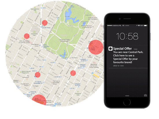
Engaging your users is one of the biggest challenges for all mobile apps. The key to doing it successfully is being truly relevant and useful to them. Spammy spray-and-pray marketing just doesn’t work anymore.
Your app users are constantly on the move and always have their mobile phones on them. To be relevant, you need to understand their whereabouts in the real world and make sure to reach out to them at the right time and place. With a geofencing app, you can do just that.
With our Geofencing demo app you can send your first notification with a geofence within an hour without a single line of code. Start today with our free trial.
So, what exactly is Geofencing?
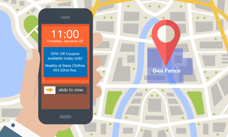
A geofence (geo-fence or geo fence) is defined as a virtual perimeter for a real-world geographic area like a restaurant or place of business. It can be a circle (radius 50m to 50 000m) or a polygon around the target location.
Geofences allow you to send notifications to app users when they are in the vicinity of, for example, your store. You can also use it to collect valuable location data about your app users, such as how often they visit your store and how long they stay there. This process is called geofencing.

Read more about the difference between geotargeting, beacons and geofencing →
Must-have features for a geofencing app
Send notifications
Send push messages triggered by places of interest within broad or precise boundaries – from entire streets or stores, to product point-of-sale.
Collect Location Data
Did sending that email campaign actually bring foot traffic to your store? Location data can help you figure it out.
Behavior-based tokens
Know how often a user of your booking app goes on a holiday, if he travels to premium or budget destinations, or if he travels with a competitor.
Retarget Users
Imagine a user who has recently visited five BMW and Mercedes dealerships – he’d be a good candidate for high-end car advertising via any channel.

Benefits of Geofencing
Reliability of technology
Our geofencing mobile marketing software relies on multiple location services. It works at all times – when your app is in background mode, while your phone is in your pocket and when the app has been actively killed.
Plug & Play integration
Easily integrate the Plot Projects technology into your app and start setting up mobile marketing campaigns to target your app users anywhere in the world through our dashboard.
Low battery use
We use cellular and WiFi networks to triangulate locations as it is the most reliable method and preferable to GPS. This makes our software incredibly power-efficient: only 0.1% of battery consumption.
High Accuracy
We aim to make our software very accurate and battery-efficient at the same time. We have complex algorithms set in place to ensure the balance between the two. The accuracy of our plugin is 10 meters.
Available for all platforms
Our software is available for all major platforms: iOS, Android, Phonegap, Appcelerator, Cordova, Ionic & Xamarin. We also have in-depth documentation and guides for easy implementation.
More granular user segmentation
You can segment different types of users ( for example demographics) to make your messages even more specific. In addition, set a cool-off period between your messages to avoid spamming.
Macro & Micro Geofences
With Plot Projects, you can create round geofences with a radius of between 50 to 50,000 meters. Encapsulate a location that is as small as a store or as big as a city! You can also decide when these should be sendable, for instance only during opening hours.
Polygons
You can also create more complex polygons to cover a specific area that you want to target, such as an airport or a specific region in your country
How to set up a geofencing app?
Wondering how to set up a geofencing app? There are many challenges involved. For instance, there are restrictions in place for both iOS and Android. There are also other things like the shape of geofences needed, how you will manage your campaigns, and setting up a solution that’s reliable and battery efficient. You might also want to complement your campaigns with the use of beacons.
While it’s possible to set up a geofencing app yourself, many companies come to providers like PlotProjects to complete the process. Our industry-leading geofencing technology is quick and easy to integrate into your apps, and allows you to bypass all the problems, bugs and limitations you could face on your own.
Get started today
Aare you ready to get started with your geofencing app? If any other questions remain, please check out our FAQs.
To find out more about how our platform can drive results for your business, contact PlotProjects today. You can try our demo app for free, or download one of our customer’s apps to see how it works. Don’t have an app? No problem. We can create a custom geofencing app using the PlotProjects technology.
Other useful resources
- 12 Geofencing Marketing Strategies to Supercharge Your Sales
- 6 Smart Examples of Geofencing to inspire Your Campaigns
- Geofencing for Mobile Apps – A Complete Guide
