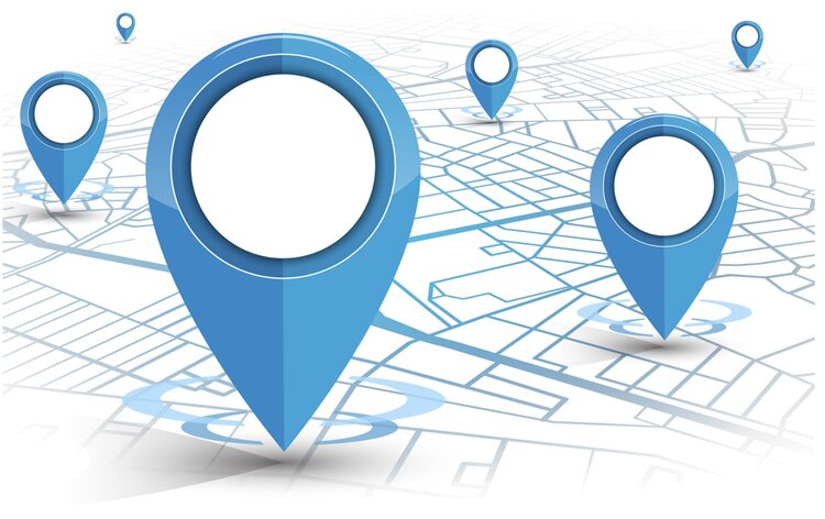
Geocoding is a vital part of location data. It converts addresses and points of interest into geographical coordinates that can be pinpointed on a map. It can be used for many things such as verifying address data, mapping delivery routes or creating location-based apps.
Any app on your phone that identifies your location is probably using geocoding software. Google Maps and many more platforms depend on this Geographic Information System (GIS) data to provide location information. Businesses also use geocode apps to streamline processes and refine marketing strategies.
If you’re thinking about creating a location-based app, geocoding is an important tool for providing accurate search and mapping functionalities. Addresses are just strings of text that can change over time, but geographical coordinates stay the same, making them the best source of accurate location information.
What is geocoding?
Geocoding is the process of converting a place name or address (like “1600 Amphitheatre Parkway, Mountain View, CA”) into latitude and longitude values (like latitude 37.423021 and longitude 122.083739). These coordinates can represent any location or point of interest on earth, whether it’s a street address, a park, a monument or a geographic feature such as a mountain.
Also known as address geocoding, it’s a subset of GIS spatial analysis, implemented through geocoding software. Used by a variety of industries from retail and e-commerce, to transport, gaming, marketing and more, geocode applications can provide location intelligence for everything, from risk assessment and location analysis, to route planning, address verification, data cleaning, and enhancing local search in GIS-based apps.
What is geocoding used for?
Pinpointing a customer based on their geographical coordinates makes for a more accurate and relevant interaction. A geocode-based app can help a pizza delivery driver deliver pizza to a person sat on a park bench. A social media app can use it to identify your location when you upload a photo, and an app like Uber uses it to identify pick-up locations.
Here’s an overview of what geocoding is used for:
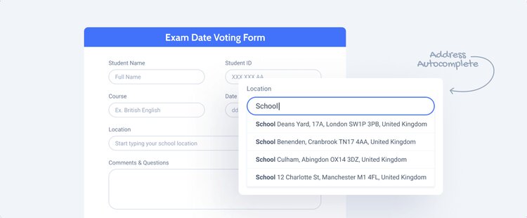
- Address autocomplete: Helping customers complete online forms and checkouts by returning accurate address data as they type, even if a user types an incorrect and incomplete address.
- Route planning: Planning the best routes for deliveries so that businesses can optimise their resources and customers know expected times of delivery.
- Measuring the distance between postcodes: Being able to accurately measure the distance between postcodes is very useful for calculating mileage claims. It speeds up the process and ensures that companies comply with HMRC regulations.
- Location analysis: Organisations can recognise patterns based on location data. Users can be organised and targeted by location to create marketing and retail strategies.
- Mapping and navigation: Geocoding underlies almost every app or GPS device that helps people find their way around.
- Local search: Discover and convert addresses and geo coordinates for better location accuracy and context in location-based apps. This quickly provides users with more helpful results and insights.
What are geocodes?
In simple terms, geocodes are the latitude and longitude coordinates of a particular address or location. The code itself is the physical coordinates that are the unique identifiers for countless places and addresses around the world. Geocoding identifies the best available geocodes for given addresses and locations.
Geocoding and geolocation – what’s the difference?
Geocoding and geolocation are sometimes referred to as the same thing, however they are different terms with different meanings. Geocoding is the process of finding geographical coordinates from an address, while geolocation refers to the physical IP location of a device, determined by its coordinates. You could say that a person’s geolocation is determined by their geocode.
Smartphones can help provide information about latitude and longitude with great precision using GIS-based technology. And almost all web browsers support geolocation features which allow users to share their location in the form of latitude and longitude, even in the absence of a smartphone.
What is meant by reverse geocoding?
As the name suggests, reverse geocoding is the same concept but in reverse. Where forward geocoding converts places and addresses to latitude and longitude coordinates, reverse geocoding converts geographical coordinates into a human-readable address or POI description.
Even when addresses are unavailable, reverse geocoding can provide corresponding addresses based on nearby landmarks. It is an essential component of mobile location-based services, converting GPS coordinates to readable street addresses which are easier to understand by the end user. This can help people find the nearest store, restaurant or other location closest to their geolocation.
Batch geocoding & rooftop accuracy
A geocoding API will typically offer forward geocoding, reverse geocoding and batch geocoding, letting you turn street addresses into coordinates and turn coordinates into street addresses, even in bulk. Geocodes can be returned with rooftop level accuracy, which is highest level of accuracy.
Benefits of geocode applications for businesses
Being able to turn a street address into coordinates and turn coordinates into a street address is hugely beneficial for businesses. Not only does it provide accurate location data, but it gives businesses the tools they need to reach their intended audience, improve customer satisfaction and streamline their day-to-day operations.
Here are some of the main benefits for businesses:
Address verification
Geocoding plays a big part in address verification technology. Also known as address autocomplete, it’s the process by which the accuracy of address data is confirmed at the point of capture. An address autocomplete API can be used in online forms and checkouts to improve data input, minimise errors and reduce failed deliveries.
Route optimization
Geocode applications can be used to pinpoint accurate delivery locations and plan the fastest and most efficient routes to an arrival point. This greatly increases efficiency and customer satisfaction. It is also helpful in monitoring road conditions or for travel and transport agencies when planning services and selecting routes.
Recognising geographic patterns
With geocoded addresses, you can spatially display those locations as points on a map and recognise patterns within the data. This can be used for things like natural resource planning, crime prevention, scientific research, urban planning and more.
Geocoding for marketing
Most businesses maintain address and location information about their customers. Geocoding lets you take this data and create a map of their locations. This information can be used for location analytics, to create accurate and cost-effective marketing campaigns that target specific clusters of customers. For instance, a retailer could use it in combination with geofencing to send location-based notifications about a special offer to customers who are nearby.
Mileage costs – measure the distance between postcodes
Geocode software lets you accurately measure the distance between postcodes, allowing you to calculate exact distances quickly and easily. This can be used to calculate accurate mileage for business expense claim forms, keeping you compliant with regulations from HMRC.
Store finder
The software makes life easier for customers by displaying addresses as points on a map. Users can easily find stores, restaurants or other locations nearby, even when they are out and about. On a mobile device, geocoding will use the device’s GPS signal to identify their geolocation, so customers do not need to enter their address to use location-based features.
Fraud prevention
Banks and other financial institutions use geocoding software to analyze where people use their debit and credit cards. This data can be used to recognise regular patterns and identify any unusual behavior.
Risk assessment
Geocoding is often used as a tool for risk assessment. For instance, insurers rely on up-to-date location data to make accurate assessments when creating insurance quotes. If a property is located next to a river, it could be a worse flood risk than a home that’s located uphill. Geocoding and GIS data can help to locate and describe addresses with rooftop level accuracy.
Gaming
GIS-based gaming relies on geocodes to provide better and more interactive location-based features. Games like Pokemon, Grand Theft Auto and Call of Duty depict real-life places and cities. Game developers work with geocode software to keep cities, battlefields, and other gaming locations accurate.
Other location-based technology
Geocoding is often combined with other location-based technology such as geofencing, beacons and geotargeting to help businesses locate, analyse and target customer locations. it’s important to consider these other technologies when implementing location-based solutions.
Geotargeting
Geotargeting is the process of delivering content to consumers based on their geolocation. On its own it leaves little room for personalisation, however using personal information such as a home address can overcome this shortfall. For instance, geocoding can help businesses target consumers based on the distance from their home address to the next event or point of sale.
Geofencing
Geofencing lets you draw a virtual fence around your stores, events or other locations. Whenever a customer enters or leaves that radius, you are able to target them with a mobile push notification. It can also help you to send targeted content to specific customer segments. Geofencing is done using geographical coordinates such as the longitude and latitude output from the geocoding process.
Beacons
Bluetooth beacons are small radio transmitters that send signals to smartphone devices nearby. Retailers often use beacons in conjunction with geofencing to personalise the shopper experience for consumers, trigger location-based notifications and share discounts and promotions. Beacons and geofencing are very useful for tracking consumer behaviour and providing context to your analytics and cross-channel campaigns.

Get started with geocoding software
Now that you undrestand the different types of geocoding and how they can enhance location-based applications, are you ready to get started? While it’s possible for app developers to look up coordinates by hand, it can be a time-consuming and complicated process!
Luckily, POI data providers like PlotProjects offer many location-based solutions including geocoding, geofencing and address autocomplete functionalities to help you enrich your datasets and provide more helpful results and insights.
A free POI database
As we are going to launch this service soon, we’re offering our POI data API with a reliable uptime for free under a fair use policy. Which means that anyone can try and use it. However, if the load of requests gets to heavy we will charge a reasonable fee to guarantee the service.
See our address autocomplete API. Or if you’d like to learn more about using POIs and geocoding for your own location data and geofencing campaigns, contact PlotProjects today.
Want to learn more?
Get in touch with us!