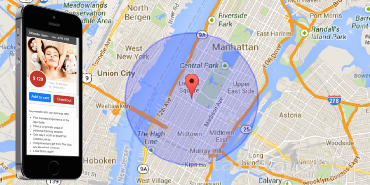
The world of geofencing might sound complicated, but it’s easier to understand than you might think. In basics terms, a geofence is defined as a virtual boundary around a real-world geographical location, while geofencing is the process of using those fences to market to consumers who enter and exit them.
Depending on how it’s set up, a geofence can trigger mobile push notifications, allow asset tracking, trigger in-app actions or collect location data. Still want to know more about what is a geofence? This Q&A guide answers some of the most common questions around the subject.

What is a geofence? A simple Q&A guide
What is the purpose of geofencing?
While geofences can be used in a multitude of ways, one of their most common uses is for mobile marketing. For example, businesses can use geofencing for sending location-based notifications to app users when they approach a specific place such as a shop, a restaurant or a festival.
The success of geofencing speaks for itself. According to statistics, more than half of shoppers visited a retailer after receiving a location-based notification. And mobile ads with geofencing have double the click through rate. It’s no wonder then that brands both big and small use geofencing as part of their marketing strategy.
But geofences aren’t all about sending ads. A big part of their value is what they can provide in terms of data and analytics. Geofences can help businesses gather important insights about consumers based on their location data. This can be used to send more relevant, personalized notifications, or to figure out what marketing strategies worked best.
What is an example of geofencing?
By now we know the answer to the question ‘what is a geofence?’ – but what are some real-world examples? One example could be a coffee shop sending notifications for special discounts to customers walking past. Or retail stores messaging shoppers about deals when they’re at their local mall.
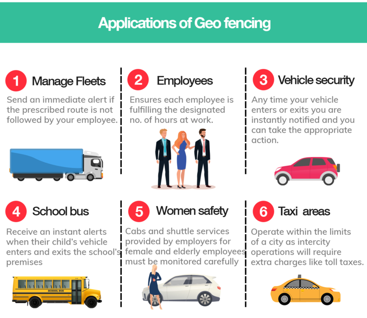
Another example of geofencing could be a business setting up a geofence around a competitor for geo-conquesting. But let’s not forget that setting up these ‘virtual fences’ offers so many other possibilities. Vehicle fleet management, human resources, livestock tracking and security alerts are just a few of the many examples of geofencing.

Who uses geofencing?
- Vouchercloud was one of the first companies to adopt geofencing – the company has used it to revolutionize high street deals.
- Burger King uses geofencing, most famously for trolling McDonalds in its Whopper Detour campaign.
- Uber sends its app users notifications about available cars in the vicinity.
- Volvo used geofencing to build brand awareness and reach customers who were out shopping for luxury vehicles.
- Starbucks uses the technology to send promotional notifications to customers nearby.
So, what exactly is a geofence? An overview
- The definition of a geofence or geo-fence is a virtual boundary that can be set up around a real-world geographical location. This could be a store, a shopping mall, a neighborhood or even a city.
- When a mobile user crosses a geofence, they can be targeted with notifications and added to advertising audiences.
- Building geofences can help businesses boost local sales, understand consumer behaviour and get ahead of their competitors.
- Geofences have many other uses beyond mobile marketing. They can be used for location tracking, monitoring assets, human resources or triggering alerts when a device enters or leaves a geofenced area.
How to set it up
Setting up geofences might seem like a simple task, but there are many challenges involved. For instance, there are restrictions in place for both iOS and Android. Android can monitor up to 100 geofences per application, while iOS can only monitor 20.
You’ll also want to think about other things like the shape of geofences needed, how you will manage your campaigns, and setting up a solution that’s accurate, reliable and battery efficient. You might also want to complement your campaigns with the use of beacons.
While it’s possible to set up geofencing yourself, many companies come to SAAS or ‘software as a service’ providers like PlotProjects to complete the process. Our industry-leading geofencing technology is quick and easy to integrate into your apps, and allows you to bypass all the problems, bugs and limitations you could face on your own.
This, along with dedicated customer support makes PlotProjects the perfect solution.
Why to use the PlotProjects SDK
Set up geofences easily
PlotProjects enables businesses to easily build geofences and target their app users with location-based notifications. With plug-and-play integration it’s simple to implement the technology into your app and target your app users anywhere in the world through our dashboard.
Micro & Macro geofences
With our solution, you can create an unlimited amount of geofences with a radius of between 50 to 50,000 meters. Send notifications triggered by places of interest within broad or precise boundaries, from stores and product point-of-sale, to entire streets, neighborhoods or cities.
Accuracy and reliability
With complex algorithms in place, our software offers high accuracy and low battery use at the same time. And thanks to our advanced functionalities, we also provide you with the most accurate location data to ensure the success of your campaigns.
Tried and tested geofencing software
Our geofencing platform has been used and tested by many high-scale publisher apps, airlines, time management apps, airports and more. Examples include, Shopfully, Futurepay, Vouchercloud, Groupon, Coca-Cola and Burger King to name just a few.
Get started with geofencing today
Now we’ve answered some common questions around the subject ‘what is a geofence’ are you ready to get started? If any other questions remain, please check out our FAQs.
To find out more about how our platform can drive results for your business, contact PlotProjects today. You can try our demo app for free, or download one of our customer’s apps to see how it works. Don’t have an app? No problem. We can create a custom geofencing app using the PlotProjects technology.
